As you drive into Tongue from Lairg to the South, round the last bend you will see this splendid view above. Some of the rooftops of the houses in the village of Tongue are visible in the lower part of the image, below the Kyle of Tongue. The causeway across the Kyle brings in the road from Cape Wrath and Durness, which lie to the West of Melness and Tongue. That road then carries on Eastwards from Tongue, along the coast to Bettyhill, Dounreay, Thurso, and John O' Groats, in the Northeast of Caithness.
The view below is Northwards from the causeway, showing one of the Rabbit Islands at the entrance to the Kyle on the left of the photo, and to the right, the peninsula of Skerray, with breakers crashing into the sandbanks off the beautiful Colbackie Beach.


Above, looking Westwards, you can see the villages of Melness, Midtown, and Talmine, on the far side of the Kyle of Tongue. You might be able to make out the sandbanks and beach at the shore.
The photo below shows the islets at the entrance to the Kyle of Tongue, with the waves from the North breaking onto the many sandbanks there.


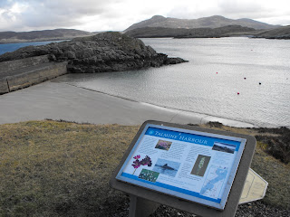
Above you can see the view Eastwards along the Sutherland coast from Talmine Harbour, with the shoreline of Skerray to the right hand side.
Below is the view to the Southeast looking across Talmine Harbour towards the community of Strathtongue in the distance across the Kyle on its Eastern shore.

The view below is looking Southwest across Talmine Bay.


Two photos looking Westwards from the road junction to the North of Tongue. Above shows the causeway across the Kyle. Below shows the view to the Southwest, with Ben Hope in the distance, beyond Castle Varrich sitting on the top of the cliff at the end of the promontory. Ben Hope is the most northerly Munro in Scotland.

Finally, the photo below shows the view from the window in the manse lounge. Ben Hope, Castle Varrich, and the Kyle of Tongue, make a stunning panorama.


No comments:
Post a Comment